Monday, February 10, 2025

Back to Lake Tyers


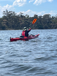
On Monday Simon and I drove for 4 hours from his place in Bunyip to the boat ramp at Lake Tyers Beach. We last visited the lake in 8 years ago. This trip was Simon’s idea and I was keen because we haven’t got away together for far too long. I was looking forward to putting the kayaks in the water even if only for a few days.

Day 1

It was a late start as I had to return a rental vehicle before setting out from home. We were ready to launch around 2:00 pm. We expected it would take 4 hours to paddle across the lake and up Boggy Creek to Nowa Nowa where Simon had booked a campsite at Mingling Waters Caravan Park.

Initially we paddled into the wind across the widest part of the lake. On the Eastern side we entered the arm that leads past the old Lake Tyers Aboriginal Mission. There is no access to that site although it is a stunning location with an interesting history. 

On this part of the lake there is some private property. Some tucked away among the trees and some other larger farming properties. Once past that it is forest all the way to Nowa Nowa. The flora and landscape is very similar to the Mitchell River below Angusvale.


We kept up a steady pace and arrived at Nowa Nowa before 7:00 pm. We only had one break to stretch and pee about halfway. There weren’t many spots where we could have got out probably due to the high level of the lake. The estuary sandbar has not been open to the sea for a long time. Around Nowa Nowa there was plenty of evidence of flooding.

We were surprised to find we were the only guests at Mingling Waters. Despite very good facilities and what seems to be a great stopping point for grey nomads we had the place to ourselves. I used the camp kitchen to prepare Chilli Con Carne with rice which went down well. I had made the Chilli months ago and dehydrated it in preparation for other trips but hadn’t used it.

I was happy to get to bed, it had been a long day.

Day 2

Another hot day was expected so we planned to get our exercise early. Mt Nowa Nowa is 7 kms from town with a some quite steep sections. We headed off after breakfast with a diversion to the nearby railway bridge lookout. It gives a view of the Nowa Nowa gorge. Unfortunately it is difficult to get a good view but it looks lovely. 


The walk up Mount Nowa Nowa accelerated our heartbeats particularly nearing the top. The views up there are great without having any particular highlights. We rested briefly before heading back down trying to keep our feet on some slippery gravel. A number of times I almost fell but managed to get to the more level section without injury. Simon was behind and landed on one knee at one point but fortunately no damage done.

Back at the general store we bought drinks and had an early lunch. It was stinking hot so we headed into the air-conditioned recreation hall at the caravan park and watched the television and napped. It was a very lazy afternoon.

For dinner we had sausages and Deb mash. 

Day 3

The weather had cooled down and we started the day by exploring upstream of the caravan park. We paddled under the Princes Highway bridge and toward the rail bridge. We did not get far and our path was blocked by large boulders that the creek flows through.

On our way back down we saw a beautiful kingfisher, unfortunately it was too hard to get a photo. Not long after a White Bellied Eagle landed in a tree just above us. It was a magnificent sight but again it was hard to get a photo.


I was feeling a little time pressure as we had a long drive ahead of us once we got back to Lake Tyers Beach. We kept up a steady pace in ideal conditions. There were lots of Black Swans  and lots of ducks. We also saw 1 lonely pelican.

We were back at the boat ramp by 1:00 pm. We quicky loaded our gear inot the car and the kayaks onto the roof racks and we on our way back to Bunyip. I arrived home just after 6:00 pm. It had been a good three days - an excellent mini-adventure. 

Friday, April 14, 2023

Mildura to Renmark (again) - 312 km

Simon missed this section of the Murray River when I paddled it back in 2018. It was one of my favourite parts of the river so when Lisa suggested I do it again, this time with Simon, it was not a hard decision. 

This leg of the journey began on April 3th, 2023 and finished on April 11th, 2023

Day 1

Long drive to Mildura. Nice pizza dinner at the Pizza Cafe in Langtree St.

Camped overnight at Apex Park. The caravan park was under water during the recent floods. On my previous trip here I was able to leave my car in a storage area at the back of the park. That is no longer a service provided by the park however they allowed Simon to leave his car parked under shelter (and charged nothing for it).


Coffee break at the bakery at Bridgewater


Day 2 - Apex Park Marker 882 to 844 Williamsville Bridge 

A quick trip into the CBD for breakfast at Langtree Cafe and for me to visit the supermarket to purchase a phone charger cord as I had left mine at home.


On the water at 9:40 am - slow paddling. Stopped after 90 minutes and walked into Merbein for lunch. It was further away from the boat ramp than I expected so we walked for 30 minutes before reaching the shopping centre. It was worth the effort for some sandwiches and a drink.


Back on the water at 1: 30 pm. Steady paddling until a cutting just before Williamsville jumped us 10 km further according to the markers. We stopped just bear the bridge where the Calder Highway becomes the Silver City Highway. A bit of difficulty finding a campsite that didn't have the stench of rotting carp.

It is illegal to return carp to the river so fishermen just throw them on the banks and leave them to rot. Unfortunately we found this in a number of places during this trip.

Pasta with tomato, onion and chorizo sauce for dinner. 

In our tents early as it was dark by 7:00 pm. 

Day 3 Marker 844 to Marker 812

Very noisy night, lots of trucks heading to and from Broken Hill. An irrigation pump on the other side of the river started up about 1:00 am.

A lovely sunny morning - packed up and on the water by 8:00 am. Arrived at Wentworth at 10:15 am. A quick walk around town with a stop for lunch and dinner supplies. 

The Tourist Information Centre allowed us to fill up our drinking water tanks. We were happy not to have to think about filtering water from the Murray which is currently an interesting shade of green. The Darling by contrast looks far more normal despite issues with fish kills 600 km up the river at Menindee.

Back at the river we met a family who were launching a motor boat. They were going to spend a week on their houseboat. Mum gave us a very large bunch of table grapes grown on their property at Berri.

Next stop was Lock 10 where we wanted to get through until we were told it was broken. The Lock Keeper Darren had joked that the lock wasn't open until Friday 1:00 pm before allowing his offsider to operate the lock for us. 

Unfotunately the outtake valve was blocked possibly by a branch or log which meant the doors could not be opened. It possibly required a diver to effect the repair. It was not going to be fixed before the busy Easter holiday weekend.

On the trailer at Lock 10


We were lucky as the lock keeper helped by transporting our kayaks on the back of a trailor to a boat ramp 1 km downstream.

This stretch of the river is beautiful - lots of birds including Darters, Spoonbills, Cormorants, Kites, 1 black swan, a kingfisher and lots of ducks.


We finished the day at the top of Bates Bend near Marker 812, on a lovely sandy beach. Sausages purchased at Wentworth and Mash for dinner.

Day 4 Marker 812 to Marker 774 3 km short of Lock 9

Both of us up before 6:00 am packing up. Leisurely breakfast and on the water paddling at 7:20 am. The weather was perfectly still and overcast all day. There were some minor showers but no major rainfall.

Lots of birds, we saw a mass take off of ducks ahead of us on the river. 1000s of birds spooked by us paddling down the river.

We stopped at the Fort Courage Anglers Club campground where we were able to top up our water from a rainwater tank. The caretaker was helpful although he was busy preparing for the Easter weekend.


Can't help but think about the origin of Fort Courage. It was the name of the fort in the 60s sitcom
F-Troop. I can't find any other references to the name. It does not appear in lists of historic NSW sites so perhaps it is simply a humorous reference to the television show.

We finished at Marker 774 - Lock 9 was just around the other side of the bend. I went for a walk after we set up camp and could hear the sound of the water going through the lock. During the flooding the bend had been under water. The high water mark on trees well inland of the river was up to my shoulder height.

high water mark at my shoulder 500 metres inland from the river


Day 5 Marker 774 to Marker 731 near Lock 8

There was an electrical storm last night from 10:30 pm onward. There was a lot of lightening and a heavy shower of rain. The thunder seemed to be some distance away so we were not concerned. The tents remained dry inside.

It was a cooler windy day. Again up before 6:00 am packing and on the water at 7:30 am. No rush though as Lock 8 wasn't open until 8:00 am. No waiting for this one, we were out the other side by 8:30 am after a 2 metre drop.


We had to push into the wind on a number of river arms. We were able to make good progress despite the wind finishing near Lock 8. We could hear it from our campsite although I was unable to get close when I went walking due to the bank being covered by willows.


Near camp there was a flock of Black Tailed Native Hens. There birds exhibit behaviours similar to chickens. It was the first time I had seen these. Simon saw some the next day and called them out as "emu chicks" - probably belong in the same category as "dog seals".


There was also a pair of Pied Butcher Birds hanging around our camp. Simon a coule of pictures of the chubbier bird. I used these pictures later to confirm the species. Curiously the overall marking matched the Pied Butcher Bird but the wing markings were similiar to the Black Backed Butcher Bird.

Day 6 Marker 731 to Marker 688

Today had everything, wind, rain, sunshine, goats, birds and 2 Locks. We were at Lock 8 right on 8:00 am and were through bu 8:30 am. Beautiful sunshine and the Murray Sunset National Park all to ourselves. The park is closed to most camping as the flooding has made the tracks inaccessable.

We were hit by a heavy shower of rain just prior to lunch. We quickly grabbed our waterproof jackets and paddled on. Rain showered us intermittently and the wind was quite gusty. 


campsite opposite Ulmarra Lodge


We arrived at Lock 7 just on 2:00 pm. Only a 5 cm drop this time. We were the 1st lockage in a week. The lock keepers work 12 days on and 2 days off. It is not strenous work and one of them suggested it can get like "ground hog day". It is certainly a job for people who like a quiet life.

The day continued witha gusty wind but the rain disappeared. We pulled up on bend opposite Ulmarra Lodge which seems to be an outstation of the main Ulmarra property. It appear there might be a party kicking off but once the kids went to bed it was a quiet night.

We had to find some slightly higher ground to pitch our tents as the ground was still quite damp and soft. In the morning behing the camp I found a wrecked car that was somewhat bogged.

Properly bogged!


Day 7 Marker 688 to Marker 640 - 48 km from marker to marker but 6 km gained in shortcuts

Ideal day for paddling - cool and dry and little wind all day. It was overcast all day and so grey that Joe lost all sense of direction near Higgings Cutting and wanted to paddle in the wrong direction. Simon talked to a camper who pointed the correction direction commenting that we should always follow the current. Later looking at the map I realised the river had looped back on iteslf and his sense of direction wasn't as out of sync as he thought.

Underwhelming sign at the SA NSW border. The SA Vic border 13 km further wasn't marked at all.


At one point we saw a large mob of emus walking through the forest close to the river. There were more people around camping today particularly on the NSW side.

Devil's Elbow    


Lock 6


Only 77 km to go to Renmark. I posted on Facebook looking for transport back to Mildura. Amy Outdoors responded. Amy had offered to drive for us back in November when we originally planned this trip but hadn't got back to me when I messaged her last week. Amy has her own Youtube channel that features her own adventures including her canoe trips on the Murray and other rivers.

Day 8 Marker 640 to Marker 604 Wilkadene Woolshed

I slept in this morning. My phone having switched to South Australian time did not wake me before sun was lighting up te tent. It was lovely and sunny but not too warm. It was pleasant paddling all day.

the paddlesteamer in the background was in the same place in 2018

Our 1st goal was Lock  6 after 20 km (J Ias not paying enough attention to the maps and predicted it would be after 10 km). We arrived in time to go through the Lock ahead of 2 houseboats coming up stream. This time the drop was 1.7 metres.

The next stop was to be Woolshed Brewery that I thought would be a Woolshend Bend. Iwas wrong again. Woolshed bend was the site of the Chowchilla Woolshed and Shearers Quarters. Realising my mistake I reassessed the map and decided that the brewery must be at Wilkinson Cutting a further 10 km. 


Has as Simon ever stopped at 1 beer before?


We arrived at the brewery and were able to purchase a Woodfired Pizza each and a schooner of Summer Ale. While we were there Berny Lohmann, another member of Murray River Expeditioners came over for chat. He paddled a "sit on" on the same stretch previousl,y a feat Simon judged more difficult than ours. 

After the brewery we paddled just 500 metres back to the river and found a lovely campsite for our last night on the river.

Day 9 Marker 603 to Marker 566 Renmark

Birds were noisy all night - At 2:30 am I woke to hear a magpie chortling and thought it must be dawn already. There was also a Boobook Owl nearby, a sound I normally find soothing but close up it was a little annoying.


Breakfast

Sunrise


Pack up and breakfast went to plan and we were on the river by 8:00. Steady progress all morning saw us arrive in Renmark ahead of our scheduled meeting with Amy Outdoors. We were able to book into the Big 4 Caravan Park and have a shower before heading out to meet Amy who brought pies and pastries and soft drink and beer to celebrate our trip.

Amy drove Simon to Mildura to get his car and then they both returned to Renamark where we all went to the Renmark Club for dinner. We were joined by Amy's partner Ian who is a keen cyclist. He was previously a FIFO worker on oil rigs. It was a lovely evening of chatting about the river, cycling and chook houses.

We finished the night packing gear into Simon's car and putting the kayaks up on the racks before going to bed.


Simon found this image on his phone during the trip


Wednesday, April 12, 2023

Lake Eildon 2023

Prior to this trip Simon reminded me that it was 3 years since we had been kayak camping. The COVID pandemic is mostly to blame and I have been out and about doing other things Oh Darling.

Last November I was a guide for a school canoe trip on the Delatite Arm of Lake Eildon. I enjoyed it so much that I wanted to explore a little more. As always the proximity of good free camping and water for paddling are very attractive to me so I invited Simon to come and help me explore.

Simon volunteered his car as transport and arrived at 9:00 am Monday morning ready to drive to Eildon township. After short stop in Healsesville for morning tea we arrived in Eildon around 11:30 am. 

 Another stop to buy a ham and cheese croissant for lunch and toilet followed by a quick drive around to find a launch point. A local pointed Simon toward the boat ramp adjacent to the weir wall and we were ready to launch.

We launched the kayaks in lovely warm sunshine and headed toward the Delatite Arm 11 km away. The lake was calm and there was a following breeze that pushed us along. After 90 minutes we landed at Coopers Point "The Pines" where we ate our lunch in the shade.


Simon relaxing in the shade

After lunch we paddled on toward the Delatite Arm putting in at Jimmy's Bend campsite. We had the campsite to ourselves. Sausages from the butcher at Garfield with Deb mash potato for dinner made for a nice finish to the day.


On Day 2 we paddled into the Delatite Arm proper to explore. I wanted to visit Crockett Island to see if the lone kangaroo was still there.

The school group I was with in November had paddled to the island to see if he/she was still there. They had discovered the kangaroo there in earlier in the year. It must have been trapped there when the water level rose cutting it off from the mainland. They had reported it to Parks Vic who were unable to locate it. As we approached the island the kangaroo appeared, looking very healthy.

After Crockett Island we paddled into The Island campsite. This was a site where I camped with the school in November. After long lunch break in the shade we hopped back in the kayaks and headed back along the shoreline in the direction we had come from. We had a long paddle into the wind. The wind did cause some waves to kick up but these were not steep and easily managed in our kayaks. Eventually we pulled up at South Maintongoon campsite in the Maintongoon Arm.

It was a little hard to find a flat spot to up our tents however it was still a very nice campsite. Another pleasant evening. Dinner was Chorizo Pasta. 

Day 3 was the return paddle to Eildon Weir. 3 hours paddling in nice sunny weather. On a sour note some thief had stolen the plastic bonnet protector off Simon's car while it was parked near the boat ramp.

56 km paddled over 3 days based on dead reckoning, proabably more when wind and drift are considered


Friday, November 22, 2019

Presentation by the Inland Rivers National Marathon Register

The last act of this journey was to record our journey in the Inland Rivers National Marathon Register. I had been trying to contact the coordinator for the register but had not been getting any response. It turned out that my email had gone to junk mail and my voicemail hadn't been heard. Finally I was able to make contact through their Facebook page administrator.

Frank Tuckwell, the Team Leader for Goolwa National Trust who maintains the register rang me while we were paddling down the Lower Murray to Goolwa. We arranged to meet at the wharf the next day for the presentation of the certificates. Getting recognition of our journey was not high on our agenda however it was nice that other people think what we have done is worthwhile.

The register records the journeys down the river of all sorts of watercraft and may not be comprehensive. You have to apply to have your journey registered so it is likely there are some who make the trip but do not register.


We frequently encounter people who say they know someone who have traveled the Murray in a "tinnie" but we haven't actually seen anyone doing that. When we have been on the river we have seen very few people except fishermen. For this reason I suspect the register is probably close to the mark in capturing accurate numbers. I am really only interested in the kayak paddlers.

According to the certificates we received we are the 11th & 12th people to complete the trip from the top of the river to Goolwa in 2019. For the record Simon is the 11th meaning he beat me over the line which is actually correct as he passed under the Hindmarsh Island Bridge ahead of me. There were 22 people complete the journey in 2018. There were 3 other kayak paddlers we know of on the river behind us when we finished.

There is a sense of achievement in being part of such a small group who completed the journey under their own power.


Tuesday, November 19, 2019

Day 13 Point Sturt to Goolwa 25 km


We woke to a grey morning with a stiff south easterly breeze. The lake looked a little choppy. 

We set off after 7:00 am and once we had passed the tip of Stony Point the choppy seas subsided. I was feeling weary and didn't have much energy probably due to skipping breakfast in order to make an early start. 

A number of times today we had to consult the map, look at the GPS and use the compass to determine which direction to go. It would have been possible to go a little offtrack and miss the right spot to enter the Lower Murray.

After 2 hours we arrived at Clayton Bay. The local cafe/store wasn't opening for another 45 minutes. We wandered down the caravan park in the hope there was a kiosk - no luck there. We decided to wait until the cafe opened and it turned out to be well worthwhile. The owner and his cook arrived just before 10:00 local time and we able to order a late breakfast  - excellent bacon & egg rolls and coffee.

The owner of the cafe was a chatty bloke who had decided to run the cafe himself after the leaseholder had left with business in a mess. We both think the business will struggle to get enough patronage to survive but good luck to him.

After our late breakfast we paddled on to Goolwa. It took another 2 and half hours before the Hindmarsh Island Bridge came into sight. We paddled under it and then landed on a old boat ramp just under the bridge. After some research we determined that we needed to paddle back 2 km to the Hindmarsh Island Caravan Park where we booked in for 1 nights.

A quick shower and we were in a taxi to Goolwa Airport. The taxi driver as well as the cafe owner earlier were surprised that we could hire a car at the airport. It is a tiny airport and the airport manager also is the Europcar agent who hires cars for pilots who land there.  They don't usually do outside hires but I had booked it through Europcar central booking so it all worked for us.

After picking up the car Simon suggested we drive to Waikerie immediately instead of waiting unit l the next morning so we spent the late afternoon and evening driving too and from. It was a good idea because he meant we could get home earlier even though it cost a little more because we had booked the car and accommodation for 2 nights.